|

|
GUIDE-BOOK
THE BEZENGI WALL
If the weather allows, the residents of the Bezengi camp can see the same picture from morning till night: a nearly regular triangle towering in the alignment of the canyon. It is the legendary Gestola, one of the gems of the famous Bezengi Wall.
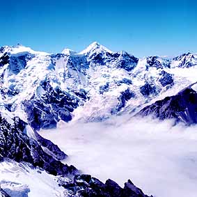 |
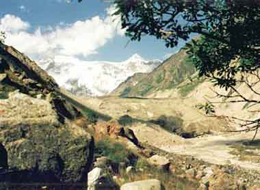
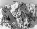
The Bezengi Wall
From left to right: Katyn - Gestola - Lyalver. Photo by I. Melnik |
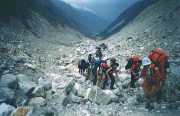
From the camp one can see only a small part of the 12-km-long mountain range called the Bezengi Wall. To reach it, you should descend from the camp straight to the tongue of the Bezengi glacier, walk along the moraine pocket, get to the glacier a little below the way up to Misses-kosh and walk along its wide plane surface for several hours. In 3-4 hours you are to get to the bottom of the Wall.
 |
|
The first hours of the climbing by the moraine pocket along the tongue of the Bezengi glacier. Photo by S. Ornitsan |
MISSES-KOSH
In about one hour walk from the camp, to the north from the glacier, there is the legendary Misses-kosh: a glade on top the green moraine, which had served as a Base Camp for many generations of climbers ascending the Bezengi Summits since 1930s.
Now it is not used any more after the mountaineering base was built. The glade became memorial: on the lower terrace there is a mountaineers' cemetery (including the graves of famous brothers Maleinov - Aleksei, died in 1935 at Dykh-tau, and Andrei, died in 1984); on the upper terrace there is a memorial rock with individual memorial boards of Russian and foreign mountaineers as well as a habitable cabin for 8-10 people. In this corner in fine weather you understand what the paradise on earth is: sun and sky, flowers and grass, the views to snow-white summits, volume and air…
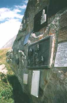 |
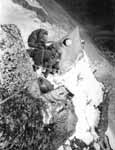
A memorial rock in Misses-kosh
|
BARAN-KOSH. KARGASHILSKY MOUNTAIN RANGE
In a 2-3 hours walk from Misses-Kosh (but in the pocket of the right-side moraine of the glacier) there is another paradise place called Baran-Kosh. It is a notable place with two lakes; you should only accurately pass from the glacier to the moraine ridge and move along it towards the Wall while the path leads you straight to the lakes.
From these overnight camps one can ascend the Kel pass. From this place mountaineers of old times used to ascend to the summits of the Kargashilsky mountain range which you passed while walking along the Bezengi glacier. Shaurtu, Salynan, Orto-Kara had good routes of 2-3 grade of difficulty. However, due to the general warming of the climate, these routes and even approaches to them became rather dangerous. That is why, nearly nobody visit the summits of the Kargashilsky mountain range nowadays.
 |
|
A view to the Bezengi Wall from the tongue of the Bezengi glacier. Photo by V. Prostebi |
THE BEZENGI WALL. JUNGI-KOSH
Having passed the traverse of Baran-Kosh, in about 30-50 minutes, you are to come to the place where one could install a guiding stone: "To the right - you'll get to Tsanner; to the left - you'll get to Jungi-kosh". The wall has already opened, but you still cannot see its left shoulder - the shoulder of Shkhara. Here you can turn to the Tsanner pass and to the overnight camps on the Black Screes. These are where one could climb the western wall from and go the Lyalver and Gestola summits.
The way to the right leads to the Austrian overnight camps and to the Jungi-kosh hut. To get there you should ascend along the moraine's nose as if changing your direction by 90 degrees. To the left behind your back there is the Semenovsky peak. Part of the routes (to south-east) has also become dangerous; but others are good to climb (some 1-2 grade routes from the circus). As you have come up the moraine, have a rest. You are nearly in the centre of the Wall. Here it is, the beauty!
 |
A view from the route of 4B grade, Jungi-tau, to the Northern massif from south (from Dych-tau to the left to Koshtan-tau to the right) |
In about an hour an even path along the moraine ridge will lead you to a hut. The three-leveled construction in the alpine style big enough to accommodate 20 people is situated at the altitude of 3,200 metres. Around it there are a lot of places for tents. These are so called Austrian overnight camps. The hut is standing opposite the western summit of Shkhara and a wonderful view to the whole Wall - up to the Tsanner pass - opens from here. From left to right you can see the Main Shkhara, 5068 m; Western Shkhara, 5057 m; Shota Rustaveli peak, 4960 m; Main Jungi-tau, 5085 m; Katyn, 4974 m; Gestola, 4860 m; Lyalver, 4350 m; 4310 Peak.
The Wall, mailed in a snow-ice armour, with a height difference of about 2 km makes a great impression.
Routes of 4B-5B grade of difficulty (there are some of 2-3 from Lyalver). Two routes of 6 grade.
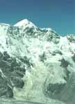 |
 Gestola Gestola
|
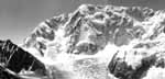
Shkhara Massif (up to Jungi-tau)
|
 |
 |
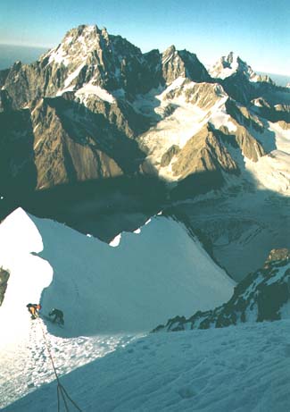
The Main Shkhara |
"Bivouac on the Shkhara rib"
|
 |
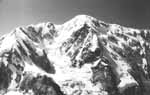 |
The Main summit of Shkhara |
Top
|